
Southampton Historical Society
Southampton Township
Bedford County, Pennsylvania
"The mission of the Southampton Historical Society is to preserve all aspects of the rich history for the residents and descendants and future generations of Southampton Township, Bedford County, Pennsylvania."

This photo, taken in Southampton Twp appeared in the Pa Department of Conservation and Natural Resources 2012 trails annual report.
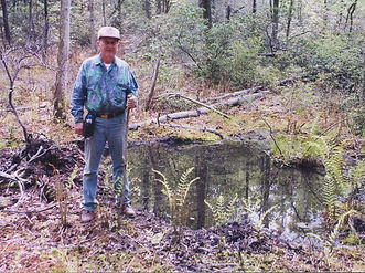
Carl Cessna
The Carl Cessna Trail section
of the Mid State Trail
Pennsylvania’s longest and wildest footpath through Southampton Township
Mid State Trail (MST) is the longest hiking trail in PA. The south end is at the MD line on Black Valley Rd in Southampton Twp. The north end is near Lawrenceville, Tioga County, at the NY border. The highest point of the entire trail across the state is at the former fire tower site on Martin Hill in Southampton Twp. The web site is http://www.hike-mst.org/ . It is marked with orange marks or “blazes” on trees or posts.
The trail began in 1969 near State College as a project of Penn State Outing Club. In 1982, the non-profit Mid State Trail Association (MSTA) formed to assume responsibility for the path, and has gradually grown to cross the entire waist of the Keystone State. There are no staff members, the volunteers do most of the work on keeping the trail open, with help from PA Department of Conservation and Natural Resources (DCNR) Bureau of Forestry.
The MST is 525 kilometers long. The trail has used the metric system since 1973. MST was the first hiking trail in the United States to use metric measure. The second edition of the guide (1973) was completely metric.
The trail through Southampton Twp was first opened in 1994, mostly by marking old trails and roads. At that time the south end was over on Imes Rd. in Mann Twp, to meet the Pine Lick Trail in Green Ridge State Forest on the MD side, and the trail at that time went down the Carnes Trail into Black Valley, past the Black Valley Prosperity Church, and through the Hewitt Covered Bridge.
In 2006, the Mid State Trail, the Green Ridge State Forest trails in Maryland, and other hiking trails from Alabama to New York State got together to form a connected hiking route called Great Eastern Trail. http://www.greateasterntrail.net In 2009 to accommodate plans from Green Ridge State Forest in MD, we moved the MST on the PA side from Mann Twp over to Southampton.
Back in 2002 if I recall right, I was afield in Martin Hill Wild Area a couple of times with my father-in-law Carl Cessna of Cessna Bros. Lumber. We had a thought to relocate MST off a dusty road and into a beautiful white pine stand, then a laurel thicket, to come onto the power line near the Wildcat Run crossing, between the former fire tower site on Martin Hill (MST’s highest point, 829 meters above sea level) and Beans Cove Rd.
Carl Cessna lived his life entirely within the highest reaches of Pennsylvania's Tiltrock Country. The woods were his school, his vocation, and his recreation. According to the book “House of Cessna, Second Series” by Howard Cessna (Berlin Publishing Co., Berlin, PA, 1935, as reprinted by Higgins Book Company) pp. 147-155, various Cessna family members at Rainsburg (including some of Carl’s grandfather John Thomas Cessna’s uncles) owned some of the mountain land on Martin Hill. These tracts and others extending from Rainsburg south to the MD line had come into the ownership of the same Howard Cessna (Carl’s grandfather’s first cousin) who sold ~16,000 acres of Martin Hill and Tussey Mountain to the state. Carl was born in 1937 in Rainsburg. His father Wilbur Cessna Sr. bought the former Perdew farmstead in Beans Cove in 1944. Wilbur Sr. had a number of portable sawmill setups, including in Wildcat Hollow on the state forest, before settling in Beans Cove. The partners in Cessna Bros. sawmill and farm in Beans Cove were Dennis, Donald Sr., Carl (deceased 2007), Clifford (deceased 2013), and originally for a time Wilbur Jr. (deceased 2010). Carl’s son Troy is among those of succeeding generations involved in the mill.
Carl passed away in October 2007 following a long fight with prostate cancer. After his passing MSTA agreed to open the new trail he had scouted years before as a memorial project, with the permission of the Bureau of Forestry. The date the State Forester in Harrisburg approved the new trail would have been Carl’s 71st birthday.
With much help from Krista Cessna and Deb Dunkle, and group volunteer efforts by Keystone Trails Association (KTA) Trail Care in fall 2008 and KTA Trail Crew in June 2009, the relocated path in the upper valley of Wildcat Run passes through a pine plantation, a laurel thicket, a 1960’s era burn area. The route passes the spring at the headwaters of Wildcat Run. Views to the southwest open from the laurel thicket over the burned area. In 2012 the KTA Trail Crew continued clearing out the Carl Cessna Trail higher up on Martin Hill to move the route off the steep power line and to come out right at the circle where the fire tower was.
Cessna Bros. Lumber has supplied most of the lumber for MST’s routed trail signs over the last few years. Now some of this locally sawn lumber forms a routed sign at the summit parking area on Beans Cove Road, welcoming MST hikers to the 3 kilometers also called Carl Cessna Trail.
More volunteers who can help clear out the trail are always welcome. The local volunteer coordinator is Ms. Deb Dunkle (she owns Dunkle Services notary in Bedford and Everett) - people can contact her on e-mail dhdunkle@embarqmail.com or 814 285-7262.
The MSTA prints a guide book and maps of the trail that can be ordered from the web site http://www.hike-mst.org/index.php/guide-and-maps or purchased from Juniata Trading in Everett. The sales of the maps and guide is the main source of income for our non-profit all volunteer association, and all proceeds help the trail.
Folks with questions can contact Deb Dunkle in Everett, check out the web site, join the MST Facebook group https://www.facebook.com/groups/midstatetrailpa/ - or contact me.
Peter Fleszar (Krista’s husband, Jenny’s son-in-law)
Vice President (volunteer)
Mid State Trail Association, Inc.
717 576-3112 cell